A potted history of Shetland around the time my story kicks off; it is the mid 19th century full dependence on the land and sea to satisfy a growing population of around 31,000 was extremely hard, crime was rife, poverty and malnutrition was on the increase and it was about to get a lot more unpleasant. It had now become apparent to landowners that sheep farming might be a more profitable form of income than fishing and crofting. Tenants thus became an obstacle, rather than an asset and so fishing tenures began to die out.
Landowners offered payments to tenants to move, followed by moderate persuasion, then heavy handed persuasion or even forced eviction, this was known in Scottish history as the period of the Highland clearances. Between 1861 and 1881 it is recorded in the Census that the population of Shetland decreased by over 8000 people or one quarter. Crofting is a form of land tenures and small-scale food production, unique to the Scottish Highlands and islands of Scotland.
Landowners offered payments to tenants to move, followed by moderate persuasion, then heavy handed persuasion or even forced eviction, this was known in Scottish history as the period of the Highland clearances. Between 1861 and 1881 it is recorded in the Census that the population of Shetland decreased by over 8000 people or one quarter. Crofting is a form of land tenures and small-scale food production, unique to the Scottish Highlands and islands of Scotland.
My only visit to date to Shetland was in 2004 for the Delling Shetland Roots Family History Week.
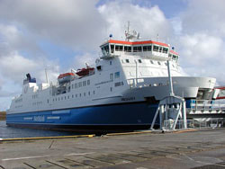
The Shetland Islands are situated 105 miles north of the Scottish mainland. Access is either by Air or Sea and therefore governed by the elements. I arrived at Lerwick aboard the 'MV Hjaltland' after an overnight sailing from Aberdeen. The crossing was smooth and enjoyable with good food and entertainment.
Lerwick, Britain's most northerly town, is undisputed capital of Shetland. With a population of over 7,000, home to around a third of the islands' people, yet it is a relatively new town and only assumed its present dominance in the 17th century; until then the principal town had been Scalloway, which had itself taken over from Tingwall as seat of the lawting. These law courts had moved to Lerwick by 1700, but the towns growth was largely due to the Dutch, who used the natural harbour as a northern base for their herring industry. Ships from the Hanseatic ports arrived here to trade and by 1625 Lerwick - taken from the Norse Leir-vik or 'muddy bay' - had a population of around 700.

My first impression was it was like stepping back in time, quaint stone build buildings right up to the waters edge no change since they were build back in 1820s. Lerwick is a name with roots in Old Norse and its local descendant, Norn, which was spoken in Shetland until the mid-19th century. The name "Lerwick" means bay of clay. The corresponding Norwegian name is Leirvik, leir meaning clay and vik meaning "bay" or "inlet". Towns with similar names exist in southwestern Norway (Leirvik) and on the Faroe Islands (Leirvík). Evidence of human settlement in the Lerwick area dates back 3,000 years, centred on the Broch of Clickimin, which was constructed in the first century BC. The first settlement to be known as Lerwick was founded in the 17th century as a herring and white fish seaport to trade with the Dutch fishing fleet. This settlement was on the mainland (west) side of Bressay Sound, a natural harbour with south and north entrances between the Shetland mainland and the island of Bressay.
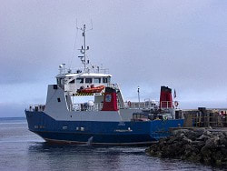
To move between the many islands the Shetlanders rely on small ferries like this one on the right. Each ferry will hold around eight family cars and about twenty walk-on passengers. With so many islands worth visiting as part of a touring itinerary, it is often a pleasant surprise to visitors how simple it is to travel around Shetland. Drive-on, drive-off ferries operate between all of the larger inhabited islands, including Bressay, Whalsay, Yell and Unst, and are fast, frequent and relied upon by locals just as much as they are by visitors. Booking is advisable, particularly at peak times. For further information on ferry times visit the Shetland
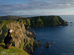
From a tourists point of view the scenic views were fabulous, the air was cleaner and wild life was in abundance. The people of Shetland were very friendly and welcomed everyone with open arms, unfortunately one week was not enough.
